Kartoza - Mapping a Sustainable Future: A Real-World Use Case for Open-Source GIS in Conservation
Explore real-world use cases of open-source GIS in conservation. Learn how Kartoza builds custom FOSS tools to help organisations manage spatial data.
Recently, a colleague and I had the opportunity to represent Kartoza at the University of Pretoria's joint Open Day for the faculties of Natural and Agricultural Sciences (NAS) and Engineering, Built Environment and Information Technology (EBIT). It was a fantastic event filled with prospective (and current) students eager to explore careers at the intersection of technology, engineering, and the natural world. However, having interacted with many of these potential future GIS professionals, I realised that a significant number of them did not fully understand how Geographic Information Systems (GIS) are actually being used in the real world. It is easy to get caught up in the academic theory of spatial data, but the practical applications are where this technology makes a tangible impact.
To help bridge that gap, this post serves as an example of a real-life use cases for GIS in the conservation field, specifically looking at how Kartoza is using Free and Open Source Software (FOSS) to help environmental organisations maximise their impact.
The Global Conservation Challenge
As we pass the midpoint of the decade, the pressure to meet the global "30x30" biodiversity targets, which aim to protect 30% of the Earth's land and oceans by 2030 is more intense than ever. Conservation organisations, government agencies and climate scientists are racing to make critical, data-driven decisions about land management and habitat protection.
The challenge? Nature is complex, dynamic and spans massive geographic scales. Effectively managing protected areas, predicting species distribution and mitigating human-wildlife conflict requires analysing vast amounts of spatial data.
For many NGOs and environmental agencies operating on tight budgets, traditional privative GIS software presents a massive roadblock. Expensive licencing fees eat into funds that should be spent on actual conservation efforts on the ground. Conservation efforts should not be hindered by vendor lock-in.
The spatial challenges in conservation
When we consult with environmental organisations they typically face a unique set of geospatial hurdles:
- Complex multi-criteria analysis: Deciding which plot of land to protect requires weighing dozens of variables, including carbon sequestration potential, species richness, water catchment impact and economic opportunity costs.
- Data democratisation: Field rangers, local communities and global policymakers all need access to the same data but in different formats (such as offline mobile data collection, complex desktop analysis and public web dashboards).
- Budget constraints: Scaling up a proprietary GIS infrastructure to accommodate hundreds of users across a global NGO often becomes financially unviable.
The Kartoza solution: FOSS GIS for the planet
By using enterprise-grade open-source tools, Kartoza builds robust Spatial Data Infrastructures (SDIs) that give conservationists the analytical power they need without the recurring license traps. A typical conservation SDI architecture includes PostGIS for heavy database management, GeoServer for secure web publishing and QGIS as the primary desktop analytical tool.
Real-world impact: Kartoza’s conservation portfolio
We build custom solutions tailored to specific environmental needs. Here are a few examples of how we have partnered with global NGOs to build bespoke, open-source conservation tools:
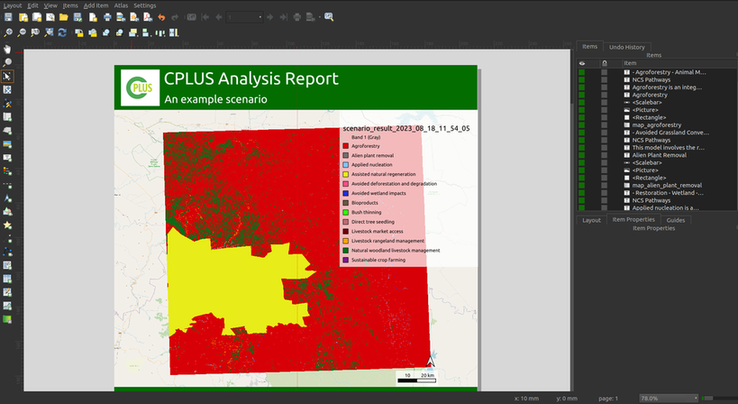
- The CPLUS QGIS Plugin: Developed in collaboration with Conservation International, the Climate Positive Land Use Strategy (CPLUS) tool helps planners identify the most critical areas for conservation investment. It aggregates complex environmental, social and economic datasets to highlight exactly where land protection will yield the highest climate and biodiversity returns.
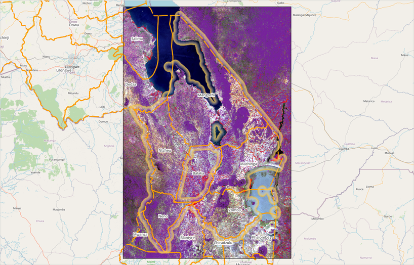
- Global Evergreening Alliance (GEA) eligible project area locator (EPAL) tool: To support massive land restoration efforts we helped develop the EPAL tool. This solution allows carbon-credit organisations easily to identify, evaluate and map land areas suitable for large-scale greening and restoration projects, speeding up the planning phase for critical climate interventions.
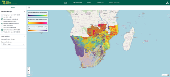
- Africa Rangeland Watch (ARW): Built for Conservation Africa, ARW empowers users to monitor and quantify land-use and climate impacts on African rangelands over time. It provides a vital dashboard that seamlessly blends remotely sensed satellite imagery with ground-based monitoring.
- Biodiversity Information Management System (BIMS): Born as the Freshwater Biodiversity Information System (FBIS) in South Africa, BIMS has evolved into a comprehensive, open-access platform for managing and visualising biodiversity data. Used by organisations like South African National Parks (SANParks), BIMS tracks everything from species occurrence to water temperature. It includes a mobile app for digital field data capture.

Expert support for mission-critical work
When you are tracking poachers, monitoring wildfires or presenting data to policymakers, your infrastructure cannot be allowed to fail.
Kartoza provides comprehensive commercial hosting and support packages for QGIS, PostGIS, GeoServer and more, offering the safety net that enterprises require. We handle the heavy lifting, from cloud hosting and server maintenance to custom software development and team training, so conservationists can focus on their mission.
For the students I met at the open day and for any organisation looking to scale its environmental impact through transparent, cost-effective and powerful spatial technology: Open-source is the path forward.


No comments yet. Login to start a new discussion Start a new discussion