Kartoza at BioMonWeek
In early May Kartoza attended BioMonWeek in Montpellier, France; the first ever European-wide conference on biodiversity monitoring. We went to show off our biodiversity information management system
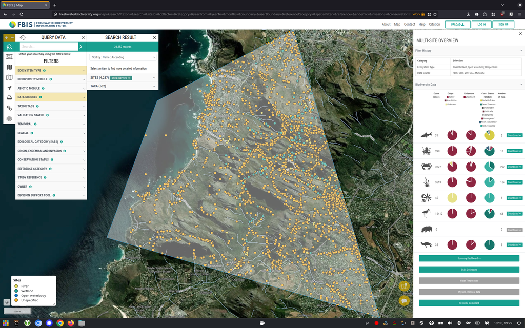
In early May Kartoza co-founders Tim Sutton and Gavin Fleming attended BioMonWeek in Montpellier, France; the first ever European-wide conference on biodiversity monitoring. We went to show off the Biodiversity Information Management System ('BIMS') that Kartoza and the Fresh Water Research Centre have developed over the past ten or so years under the careful stewardship of Dimas tri Ciputra, senior developer at Kartoza. BIMS is Open Source (AGPL) and provides a complete platform for recording biological occurrence records, managing taxonomy and for reporting and exploring one's data with numerous dashboards that help one to attain insights about the state of biodiversity in one’s area of interest.
Public, enterprise, academic
It was really interesting to see other companies like Kartoza working in partnership with academia and NGOs in the biodiversity informatics space, such as:
- Beeodiversity, who are doing terrestrial bio-monitoring with bees! It is a really clever system whereby they analyse the pollen that bees bring back to the hive and then identify species, pesticides, etc. from their forage area
- Companies like SimplexDNA who are gearing up for coming glut of eDNA and other monitoring data
- An EU Horizon project coordinated by Dr Werner Rom for robotic underwater monitoring buoys
At Kartoza our business model is to provide professional services within the open source geospatial ecosystem and we bring the same open knowledge ethos to our work in the bioinformatics world. We believe we add a lot of value when commercial entities can complement projects typically spawned in academia: Long term persistence of effort, rapid application of learning, professionalism of system development and an eventual career on-ramp for academic teams members who complete their studies and want to apply their knowledge in the commercial world.
If we are going to take looking after our planet seriously, it has to be done in partnership among government, academia and enterprise to ensure that no skills or value are left on the table. Kartoza is working hard to participate in this space.
Interesting takeaways
For a first conference, BioMonWeek was very well organised and attended with around 360 attendees from Europe and beyond. The point of the conference was to provide a community of practice event for organisations and individuals carrying out biodiversity monitoring activities. There were so many interesting threads of discussion within the conference, it is probably better to point you to the conference page on themes and sessions if you want to get a sense of all of the content covered.
European countries and institutions seem to be very busy responding to the various EU Directives that involve biodiversity monitoring, including a looming one to define and achieve ecosystem restoration targets. The was a big emphasis on biodiversity monitoring being way more than occurrence monitoring and how it needs to encompass ecosystem and other context monitoring. What are novel data sources and types in our geospatial domain, like eDNA, DNA metabarcodes and acoustic signatures, are now mainstream in the 'biomon' world. We will be grappling with how to handle these, along with all the domain specific interchange protocols and analysis and visualisation techniques, so we can enrich our BIMS tooling and grow to be a more significant actor in this exciting and important field. As ever in our field, the FAIR principles apply and we are staucnh advocates of implementing them in everything we do. A like-minded initiative we came across was LUCA, a global, open biodiversity infrastructure.
If you come from a general GIS or geospatial background, you’ll be interested to know that practitioners of biodiversity monitoring are finding ways to apply all the latest technologies in the geospatial field to their discipline. A rich array of projects use AI and Machine Learning (ML), drones, audio recording and analysis, remote sensing, image analysis, internet of things, remote sensors, data cubes, etc. Some of applications of these technologies are really novel.
From Kartoza's perspective as an open source GIS company, we see considerable opportunity for the use of open source in the realm of biodiversity monitoring. By definition these projects are long duration activities (often continuing ad infinitum) and the need for a consistent and sustainable software environment that lives beyond proprietary vendor market relationships is critical.
In terms of spatial technologies, open source and open standards already provide a rich toolbox. This starts with traditional simple features data storage and analysis, dealing with points (e.g. occurrences), lines (e.g. transects) and polygons (e.g. ecosystem boundaries). Equally well supported in the open source ecosystem are raster storage and analysis. Ecologists and biologists also have excellent use cases for spatio-temporal data storage in vector and raster data cubes. Monitoring is also a huge generator of data and biologists can make excellent use of the emerging cloud native technologies like Apache Iceberg and Icechunk.
Here to help
If you have a project in the intersection of open source, geospatial and biodiversity, please reach out to us, Kartoza would love to work on it with you!
BioMonWeek2026 was co-organised by:
Tim Sutton
Tim started his career by working in Nature Conservation in South Africa. Some years later, around 1998, an opening in the newly formed GIS group in the organisation where he worked presented an opportunity to combine his love of the environment with his enthusiasm for computers. What followed quickly became a deep dive into GIS (including obtaining a Master's Degree in GIS and Environmental Studies) and Open Source. He discovered Linux, also around 1998, and became an ardent fan of using and creating Open Source software. The announcement of the first release of QGIS in 2002 was another key milestone, with Tim quickly becoming deeply involved in the development of QGIS, as well as helping to build the community platforms and governance structures around the project. Formerly the QGIS.org Board Chair, Tim was awarded perpetual Honorary QGIS PSC Member status in 2018 and continues to play an active role in many aspects of the QGIS project. Tim is also engaged in the broader Open Source GIS ecosystem, including having the honour of being an OSGEO Charter Member and promoting the wide array of world-changing Open Source GIS tools provided under the OSGEO umbrella (and beyond) to pretty much anyone who will listen.


No comments yet. Login to start a new discussion Start a new discussion